Coe, Brothers & Katahdin | 6/20/25
- Izzy Risitano
- Jun 27, 2025
- 10 min read
Birthday Baxter 2025- a trip of slides, laughter, side characters, and whiskey. I booked a site at Abol 3 months ago without checking if anyone was available- determined to go no matter what. Yet, when it became clear that Liz and Dave could join me for the weekend, the trip's potential blossomed. On our 3-day trip, we explored Niagara Falls, Brothers & Coe, and Katahdin back to back.
When we rolled into camp on Thursday, I couldn't have been happier to have my phone on airplane mode: no Slack, no news alerts, and no doom scrolling. Behind setting up camp, I rallied to go for a walk at Daicey Pond so we could explore Big & Little Niagara Falls. In addition to grandiose views, Baxter is also home to many low-elevation hikes for rainy afternoons. While I'd have liked to check out Daicey and Kidney Pond as well, 5-hours of driving turns out to be tiring! I don't have much to say on this one as we followed a great footpath on the AT the whole time, but the pictures speak for themselves.

As Friday morning came, the previous night's storms had affected our sleep. Having my tent lit by with lightning every 5 minutes and wondering if my new tent would withstand downpours was not conducive to falling asleep before midnight. The weather did not, however, change our game plan for the day- Fort, Coe, and Brothers. We started before 7 and with a check of the register regarding Mt. Coe trail as "blown down and disorienting," we carried on. The first 1000 feet gain nicely through a beautiful forest alongside a stream over 1.3 miles. While rising out of the gates, this was a great section of trail to adjust to the moisture and humidity to come. At the base of the Coe/Marston junction, we wearily headed right to Coe Slide despite the recent rain.

Like much of Baxter, Coe Slide made me wonder "Am I just too afraid?" Despite owning the Maine Guide, it has provided me almost no insight into what I've gotten myself into when hiking in Maine. My only indication we were in for a ride today was Rebecca Sperry's black-slime-covered Instagram post of Coe from a few months ago. Hopefully, this blog post can serve as an example of what hiking Baxter slides is like when you are stubborn yet also afraid of scree and slab, like me.

Up until the first section of black slime, which looked exactly like Rebecca's post, the Coe slide trail was stunningly maintained. Yet as we began up the first section of the slab, I kept wondering when we'd duck off to the right and back into the woods. As it turned out we did not, and the slab climb required numerous techniques. I bear crawled, side-hugged, talus scrambled, and tree-fought up to the summit, only having about 3 of my classic exposure freak-outs. This trail was comparable to the North Tripyramid Slide only shorter and slimier. For the most part, I had fun with the exposure until the very top when Dave pointed out rain clouds moving in. With some panic, I forced myself up as the rain began to start, and never stopped. Talk about a religious experience.


As we topped out Coe, we soon understood the comments of delirium along the way. While the blowdowns didn't throw us off course, they were relentlessly annoying. Over, under, around, through- all of which left my exposed legs cut and bruised to all hell. They slowed us down at least an hour, frustrating given how demanding the loop is in ideal conditions anyhow. When we finally broke through to South Brother, we'd only seen two other parties who were moving much faster than us. Dave and I slack-packed up to South Brother, saw nothing, then dipped right back down to pick up Liz and continued to North Brother.

There were still several more blowdowns before we intersected with Marston, where evidence of travel finally sprung up. The difference between hundred highest and 4000-footer trails is always easy to spot- but here the difference was magnified. Suddenly, each blowdown was cut perfectly off the trail, sections of the spur rerouted to avoid beyond-help blown sections, and the footpath was excellent. Even though North Brother's spur was steep, I did enjoy the trail until we broke the tree line.
As we emerged to a boulder problem, the winds and rain increased drastically. Knowing Fort was out of the cards then and there- I offered to bail since I had to return, but Dave pointed out it was just a couple hundred feet away. We carried on quickly and silently as the wind whipped rain on our faces. At the summit, I grabbed my third summit selfie of the day, wherein each of my appearances deteriorated as the weather did.
Coming off of North Brother was fairly quick, but body warmth was more difficult to earn. By this point, everything in my backpack was saturated so I kept moving in my tissue-thin rain jacket. To my greatest surprise, the Marston trail was dreamy all the way through. At first, we descended fairly level atop bog bridges and then began to drop steadily as we skirted the corner of the cliffs west of Brothers.
On account of Marston being switchbacked, full of stairways, and well-maintained- I'm excited to return to Fort on a nicer day. While I don't regret hiking in the rain & wind for the experience we had, I would like to see North Brother's famous views!

When we returned to the Slide Dam Picnic Area, the clouds had lifted enough to see the slides off Doubletop Mountain across the street. They were so massive, even looking at the slope map now I'm curious how that hike is in terms of scare factor!
Back at camp that night, we had a lovely evening of fire-roasted kielbasa and formulated our Saturday plan, which transitioned from a Knife Edge loop to Abol due to physical concerns from all but mostly me. A fun fact about myself is that I refused to go down escalators for most of my childhood because my center of gravity was/is THAT bad. Isn't it funny that I put myself in these situations for fun now? Onward & upward!
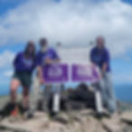
For many reasons, Saturday's weather was a dream. For one, summiting wasn't promised because we refused to do Katahdin in less-than-ideal conditions. But second-most importantly, the three of us planned to hike Katahdin for our 48-Peaks Alzheimer's Longest Day hike- and what summit is a greater honor than Katahdin?
With our trail proximity camping at Abol, I woke up more chipper than I typically do whilst tenting. I chowed down on a Trader Joe's coffee cake muffin and a cold hot dog as we did final gear checks to ascend the mighty Katahdin. With a sign out at the ranger's office, team Baxter Alz-Stars began our short but mighty hike up Katahdin.

The first mile of Abol eases into the climb through a mixed forest over a surprisingly wide footpath. Though the trail was wet from Friday's storms, I should note there was virtually no water on the rest of the hike- enjoy a water carry while you scramble! Speaking of dry trail- after that first mile Abol transitions to a low-elevation slide base, characterized by loose rocks (no matter at this grade), sand, and full sun exposure. The early tree break awarded our first views of the various lakes southwest of Baxter- namely Moosehead Lake.

The climb as I knew it began right where Gaia displayed a set of binoculars at 3,230 feet. This spot is otherwise known as Rabbit Terrace, where I sat to enjoy some dried mangoes as Liz yelled through the trees, "Izzy there's bunnies!" and they came barrelling for my mango. Rude!

When all three of us joined up at the viewpoint, Dave made a point to act frazzled he'd lost his pet rabbit on the trail- which the kind passersby did not understand was a joke. Nonetheless, the rabbits were mesmerizing to watch- maybe they were hares, but their speed and curiosity were unlike the bunnies I see on my suburban runs.
Up from Wonderland, the trail's intensity picked up. Along the trail's ~10-year-old reroute, the trail was particularly well done. I was impressed by the frequency of the blazes and occasional steps at the beginning of the tough stuff. Despite the undoubted difficulty, I had a great time with the early part of the scramble from 3200-4000 feet of elevation. This section reminded me of the Daniel Webster Scout trail up Madison in every way- terrain, views, and sun exposure!

As we reached 4000 feet and started to climb the original Abol trail up the switchback-less section, I swiftly gave up my lead. Thankfully, Dave and Liz are accustomed to my trail fears and moved ahead. I felt that my holdback on the ascent was overthinking how I'd descend- more on that later.
Among the worst moments of gaining 500 feet in 0.16 miles were: "Oh great, there's loose dirt!", "Death Pivot / Giant Step Crevice", and Thoreau's Asshole. Before I get clocked for being dramatic, I told you already that this is from the perspective of somebody who wouldn't get on escalators half a lifetime ago!
"Oh great, there's loose dirt," is exactly what it sounds like- this was more of a problem going down but it is right below the Giant Step Crevice, for which I got up fine (you'd understand if you've ever seen my quads) but was much more difficult to descend. My advice is to avoid a massive pack that holds you up on everything!
The greatest struggle of my whole day was Thoreau's Asshole. Now it obviously isn't called that, but it's fitting given his thoughts on the mountain. You'll know this one when you see it- a slippery 7-foot angled slab topped off with a rock overhang your backpack will surely get stuck on to your left and a gripless larger rock on your right. There is also a hole you can squeeze through if you are smaller than a woman's size 10- I know because I was the LIMIT. Again more on that later- way easier going up than down.

Beyond my three wonders, Abol pretty much tops out all of a sudden with exceptional 360 views from the Tableland. Once we hit Thoreau's Spring, we had about a mile of the Hunt trail until the summit. That part of the trail was a breeze- sweeping views of the Brothers and Doubletop to the west, and the ever-growing sight of Katahdin as we continued to the summit.


Looking at Katahdin from just a mile away was more incredible than I ever could've imagined. I'm not sure any summit compared- Katahdin was my 83rd Hundred Highest Peak, atop all the other stuff I've seen and summited; yet still, the sight of Knife Edge made me feel like this was my first big mountain. As the famous Katahdin sign came into view, I was still in disbelief I'd finally get to peer down to the Great Basin. Seeing it didn't make it any easier to believe!


Standing on top of Katahdin is emotional- people finishing the AT, Maine families summiting with all their kids for the first time, and folks sharing their stories about Alzheimer's with us because of our shirts. Then on top of all that human experience is seeing your past and present all in one view. I peered over at Hamlin, the height of a crazy yet beautiful time in Baxter 2 years ago. I looked towards the Travellers with a chuckle for my friend Diane, who did them yet had no recollection of the difficulty. I looked down at Chimney Pond, where Liz, Dave & I hope to make more memories soon. Finally, I looked way off past South Branch and appreciated how much more of this life-changing wilderness I have to explore.
We quickly ate up an hour drooling at the views, and eventually had to make a call on Hamlin or early camp. Despite our lamenting, we ultimately chose to head back to camp so we could enjoy more time by the fire. This would turn out to be an excellent decision- while the Tablelands were rather fast, I believe the mile and 2000-foot drop took us 2 hours. Thoreau's Asshole was the most notable of my wonders- as I deliberated how to go down given my fear of going backward until a nice Québécoise lady demonstrated her method. I never caught her name but I feel as though we got to know each other well...
After passing her backpack down, she flipped over on her stomach and wiggled through the hole backward with some guidance on where to put her feet. She was graceful and quick- the opposite of me. As I went to replicate her art, I first wondered if I'd even fit then went all in. I needed a good bit of coaching to place my feet on the other end and this will go down as something I hope to never do again.

Past that unique descent, the pivot made for another tough situation requiring a turn towards the mountain as my backpack pushed me the opposite way off a ledge. A trail vest would've solved that, at least the getting stuck part.
After those three known struggle points, "Izzy Kryptonite" as Liz and Dae call it, the rest was smooth sailing considering the rate of elevation loss. At this point, the only bother was sun and windburn, which had exhausted and dehydrated us a bit. That said- getting back to the canopy and sound of Abol Stream was a delight.
Getting back into camp felt fantastic. Staying trailside was great as we got to see lots of the hikers we met throughout our day in a relaxed setting. The privilege to not only experience Katahdin but share the same joy with people you just met is a lovely feeling. It's why I love Baxter so much, everyone there has been dreaming of it for months and planned for it long before then. In a lot of ways, Baxter is a reminder that some childlike wonders never lift. I'm happy to say that my wonder is the gates of Park Tote Road- where every moment within them has been unforgettable.
Big & Little Niagara Stats:
2.53 miles, 126ft gain
Coe & Brothers Stats:
9.92 miles, 3,856ft gain
Katahdin Stats:
7.41 miles, 3,863ft gain